Trade winds
Prevailing easterly winds that shaped global navigation and climate.
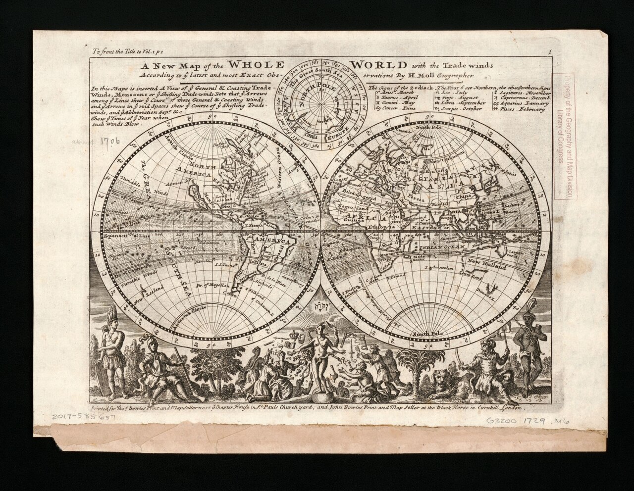
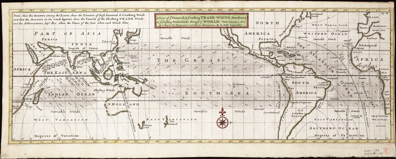
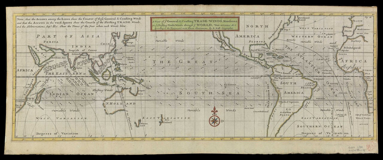
The trade winds, or easterlies, are prevailing winds that blow from east to west near the equator. In the Northern Hemisphere, they come mainly from the northeast; in the Southern Hemisphere, they blow from the southeast. These winds get stronger during winter and when the Arctic oscillation is in its warm phase. For centuries, sailing ship captains relied on them to cross the world’s oceans, which helped enable European colonization of the Americas and the creation of trade routes across the Atlantic and Pacific.
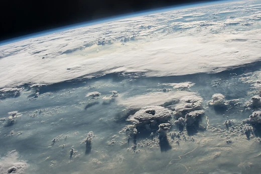
In meteorology, the trade winds steer tropical storms that form over the Atlantic, Pacific, and southern Indian oceans. They also bring rainfall to East Africa, Madagascar, North America, and Southeast Asia. Shallow cumulus clouds are common in trade wind regions, but they are kept from growing taller by a trade wind inversion—a layer of descending air from the subtropical ridge. When the trade winds weaken, neighboring landmasses tend to get more rain.
These winds also carry nitrate- and phosphate-rich dust from the Sahara to Latin America, the Caribbean, and parts of southeastern and southwestern North America. This Saharan dust sometimes shows up in sunsets across Florida. When the dust travels over land, it suppresses rainfall, turns the sky from blue to white, and leads to more red sunsets. It also harms air quality by increasing airborne particulates.
**History**
The word “trade” originally came from a 14th-century Middle English term meaning “path” or “track.” By the 15th century, the Portuguese had recognized the importance of the trade winds—calling them *volta do mar*, or “turn of the sea”—for navigation in the North and South Atlantic. To sail from West Africa to Europe, they had to head west and northwest, then turn northeast toward the Azores, and finally east to the mainland. To reach South Africa, they learned to go far out into the ocean, head for Brazil, and around 30°S turn east again. (Following the African coast south meant sailing against the wind in the Southern Hemisphere.) In the Pacific, Europeans did not understand the full wind circulation—including both the trade wind easterlies and higher-latitude westerlies—until Andres de Urdaneta’s voyage in 1565.
A sailing ship captain looks for a course where the winds blow in the direction of travel. During the Age of Sail, these prevailing wind patterns made some parts of the world easy to reach and others difficult, directly shaping European empire-building and modern political geography. For example, Manila galleons could not sail into the wind at all.
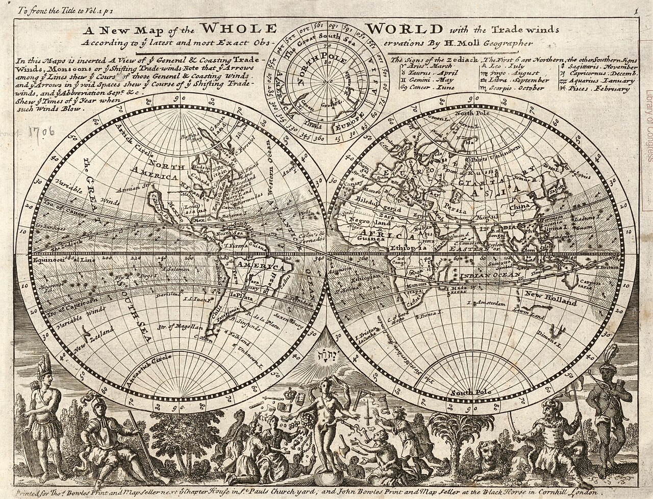
By the 18th century, the trade winds’ importance to England’s merchant fleet for crossing the Atlantic led the public and etymologists to link the name with the later meaning of “trade” as foreign commerce. Between 1847 and 1849, Matthew Fontaine Maury gathered enough data to create wind and current charts for the world’s oceans.
**Cause**
The trade winds are part of the Hadley cell: surface air flows toward the equator, while air aloft flows toward the poles. Near the equator, a low-pressure area of calm, light winds is called the doldrums, the near-equatorial trough, the intertropical front, or the Intertropical Convergence Zone. In monsoon regions, this zone is also known as the monsoon trough. Around 30° north and south, air descends in subtropical high-pressure belts called subtropical ridges. This sinking air is dry because it lost its moisture as rain when it rose over the equator. This warm, dry air—known as a superior air mass—usually sits above a warm, moist maritime tropical air mass. When temperature increases with height, it’s called a temperature inversion; in trade wind regions, it’s the trade wind inversion.
Surface air flowing from these subtropical high-pressure belts toward the equator is deflected westward by the Coriolis effect. This produces winds from the northeast in the Northern Hemisphere and from the southeast in the Southern Hemisphere. Since winds are named for where they come from, these are called the northeasterly trade winds and southeasterly trade winds. The two meet at the Doldrums.
As they blow across tropical regions, air masses heat up from more direct sunlight. Those that develop over land are drier and hotter than those over oceans, and they travel northward on the western edge of the subtropical ridge. Maritime tropical air masses are sometimes called trade air masses. All tropical oceans except the northern Indian Ocean have large areas of trade winds.
**Weather and biodiversity effects**
Clouds in trade wind regions are usually shallow cumulus, no more than 4 kilometers (13,000 feet) tall, capped by the trade wind inversion. During the cold season, the trade winds blow more from the direction of the poles (northeast in the Northern Hemisphere, southeast in the Southern Hemisphere) and are stronger in winter than summer. For example, the windy season in the Guianas, in low-latitude South America, runs from January to April. When the phase of the Arctic oscillation is warm, the trade winds strengthen.
- field
- Meteorology, Navigation
- known_for
- Steering flow for tropical storms; transport of Saharan dust; enabling transoceanic sailing routes
- characteristics
- Blow east-to-west; northeast in Northern Hemisphere, southeast in Southern Hemisphere; stronger in winter
- associated_phenomena
- Trade wind inversion, Hadley cell, subtropical ridges, doldrums
Lore & Background
The term 'trade winds' originally derives from the early fourteenth century sense of 'trade' meaning 'path' or 'track'. The Portuguese recognized their importance in navigation as early as the 15th century, using the volta do mar ('turn of the sea') to sail from West Africa westward and northwestward, then northeast toward the Azores, and finally east to mainland Europe. They also learned that to reach South Africa, they needed to go far out into the ocean, head for Brazil, and around 30°S go east again, because following the African coast southbound meant sailing upwind in the Southern Hemisphere. In the Pacific Ocean, the full understanding of the global wind circulation—including trade wind easterlies and higher-latitude westerlies—was not achieved until later centuries, though navigators had already begun exploiting these patterns.
Reader's Guide
The trade winds have been central to both meteorology and human history. In meteorology, they act as the steering flow for tropical storms that form over the Atlantic, Pacific, and southern Indian oceans, and cause rainfall in East Africa, Madagascar, North America, and Southeast Asia. Shallow cumulus clouds within trade wind regimes are capped by a trade wind inversion caused by descending air aloft from the subtropical ridge. The weaker the trade winds become, the more rainfall can be expected on neighboring landmasses. The winds also transport nitrate- and phosphate-rich Saharan dust to Latin America, the Caribbean Sea, and parts of southeastern and southwestern North America. This dust suppresses rainfall, changes the sky from blue to white, increases red sunsets, and negatively impacts air quality by adding airborne particulates. Historically, during the Age of Sail, the pattern of prevailing winds made various points of the globe easy or difficult to access, directly affecting European empire-building and modern political geography. By the 18th century, the importance of the trade winds to England's merchant fleet led both the public and etymologists to identify the name with 'foreign commerce'.
Did You Know?
- The trade winds are also called easterlies and blow from east to west in Earth's equatorial region.
- ENSO significantly affects trade wind strength, but the Atlantic Multidecadal Oscillation's direct influence is less clear and not canonically ranked against the Arctic Oscillation.
- Saharan dust transported by trade winds brings vital phosphorus and other fertilizers to depleted Amazon soils.
- The Portuguese used the trade winds in the 15th century for navigation, calling the pattern the 'volta do mar'.
Navigation and the Age of Sail
The trade winds shaped maritime history profoundly. Portuguese sailors in the 15th century recognized their navigational value, calling them the volta do mar—the 'turn of the sea.' From West Africa, they had to sail west and northwest before turning northeast toward the Azores and east to Europe. Reaching South Africa required sailing far out, heading for Brazil, and turning east near 30°S. During the Age of Sail, these prevailing winds made certain routes easy while rendering others nearly impossible—Manila galleons, for instance, could not sail into the wind at all. By the 18th century, England's merchant fleet depended so heavily on these winds for Atlantic crossings that the public and etymologists began associating the name with 'trade' in the commercial sense.
The Engine Behind the Winds
The trade winds are a surface expression of the Hadley cell, where air flows toward the equator at low altitude while aloft the flow moves poleward. Around 30° latitude in both hemispheres, air descends into subtropical high-pressure belts called subtropical ridges. This sinking air is dry, having shed its moisture as precipitation during its ascent over the equator, and it forms a warm superior air mass sitting above the moist maritime tropical layer below. The resulting temperature increase with height creates a trade wind inversion. Once this surface air begins flowing equatorward, the Coriolis effect deflects it westward in both hemispheres, producing the northeasterly winds of the north and the southeasterly winds of the south. The two streams converge at the doldrums—the intertropical convergence zone—where calm, variable winds prevail. Continental air masses that develop over land are drier and hotter than their maritime counterparts, which are sometimes called trade air masses. All tropical oceans except the northern Indian Ocean host extensive trade wind areas.
Clouds, Rainfall, and Seasonal Rhythms
Within trade wind regimes, the atmosphere produces a distinctive cloud signature: shallow cumulus formations that rarely exceed four kilometres in height, their vertical growth arrested by the trade wind inversion above. The winds themselves intensify during the cold season and weaken in summer, a pattern visible in places like the Guianas, where the windy season runs from January through April. The Arctic oscillation modulates this further—its warm phase strengthens tropical trade winds, while the cold phase weakens them. When the winds slacken, rainfall expands across neighboring landmasses, with Central America receiving notably more extensive precipitation. In July, the westward-moving trade winds south of the northward-shifting subtropical ridge push northwestward from the Caribbean into southeastern North America, reaching Florida and the Gulf region. These seasonal and oscillatory shifts mean that the trade winds are not a static feature but a dynamic system whose strength directly governs how much moisture reaches tropical coastlines.
Saharan Dust and Downstream Consequences
Beyond their role in steering tropical storms and generating rainfall across East Africa, Madagascar, North America, and Southeast Asia, the trade winds serve as a long-distance conveyor for Saharan dust rich in nitrates and phosphates. This mineral-laden particulate matter is carried across the Atlantic to all of Latin America, the Caribbean Sea, and portions of southeastern and southwestern North America. On occasion, the dust is visible in Florida sunsets. When the Saharan plume travels over land, it suppresses rainfall and shifts the sky's appearance from blue to white, while simultaneously intensifying red sunsets. The presence of this dust negatively impacts air quality by increasing the count of airborne particulates in downwind regions. The nutrient-rich composition of the dust—carrying nitrates and phosphates across thousands of kilometres—means the trade winds also function as a vital link between the arid Sahara and the ecosystems of the Caribbean, Latin America, and the American Southeast, delivering mineral content that shapes local atmospheric and environmental conditions.
Gallery
Frequently Asked Questions
What are trade winds in meteorology?
Trade winds are the prevailing easterly air currents that circulate across Earth's equatorial belt, flowing from east to west. They are also commonly called easterlies and form a key component of the Hadley cell circulation.
Which direction do trade winds blow in each hemisphere?
In the Northern Hemisphere they arrive from the northeast, while in the Southern Hemisphere they come from the southeast. Both hemispheric branches tend to intensify during the winter months.
How do trade winds influence tropical storms?
They serve as the primary steering flow that guides tropical cyclones along their tracks across ocean basins. Their strength and direction largely determine where a storm will travel after formation.
Why were trade winds historically significant for sailors?
For centuries, captains of sailing vessels relied on these steady easterly currents to cross the Atlantic and other oceans. This made European colonization of the Americas and the establishment of global trade routes possible.
What role do trade winds play in transporting Saharan dust?
The easterly flow carries fine mineral particles from the Sahara Desert westward across the Atlantic toward the Caribbean and South America. This dust transport is a well-documented characteristic of the trade wind system.
More in Meteorology 1-24
Spotted an error? Know more?
This is a living reference — every entry is fact-audited, and reader corrections feed straight into our audit queue. Suggest an edit · See this site's audit record